Census Geographies Explained
Relationship Between Geographies | Formation and History | Special Geographies
Relationship Between Geographies
Just as counties nest within states, and states nest within the country, the most commonly used census geographies nest within each other. This nested structure is illustrated below:
|
Counties |
2010 Census Geographies for Wake County, NC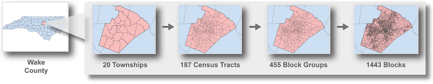 |
Each level provides complete but unique coverage of the level above it. This enables an extremely detailed examination of the characteristics of the entire country.
Formation and History
Tract and Block Group Census geographies are formed on the basis of population density.
|
Geography
|
Min Pop in 2000
|
Max Pop in 2000
|
Optimum Pop in 2000
|
|---|---|---|---|
|
Tract
|
1,500
|
8,000
|
4,000
|
|
Block Group
|
600
|
3,000
|
1,500
|
Census Blocks are the smallest level of geography you can get basic demographic data for, such as total population by age, sex, and race. They are not, however, delineated based on population, and in fact, many Census blocks do not have any population. Blocks also are not used to report American Community Survey (ACS) data - ACS data only go to the Block Group level.
Over time, tracts have been subdivided in a systematic way to provide researchers with some sense of the history of the geographies. However, the country was not fully "tracted" until 1990. Thus, researchers attempting time series comparisons of data prior to 1990 at the tract level are limited to extrapolated estimates, or must use county-based data. Such history is not preserved by either block groups or blocks.
Special Geographies
The Census Bureau forms special geographies for special purposes.
CDP - Census Designated Place - the statistical counterpart of an incorporated place for the purpose of presenting census data for an area with a concentration of population, housing, and commercial structures that is identifiable by name, but is not within an incorporated place. The Census Bureau solicits local input to identify such places. In North Carolina, the community around Fort Bragg, although significant, has not always been incorporated and in some unincorporated years has appeared in the census data as a CDP.
CBSA - Core-Based Statistical Area - 2003 replacement for 1993 Metropolitan Statistical Area geography. "Core Based Statistical Area" is a collective term for both metro and micro areas. A metro area contains a core urban area of 50,000 or more population, and a micro area contains an urban core of at least 10,000 (but less than 50,000) population. Each metro or micro area consists of one or more counties and includes the counties containing the core urban area, as well as any adjacent counties that have a high degree of social and economic integration (as measured by commuting to work) with the urban core.
PUMA - Public Use Microdata Area - A geographic entity for which the U.S. Census Bureau provides specially selected extracts of raw data from a small sample of long-form census records that are screened to protect confidentiality of census records. Data users can use these files to create their own statistical tabulations and data summaries.The extract files are referred to as public use microdata samples (PUMS). PUMAs must have a minimum census population of 100,000 and cannot cross a state line. They receive a 5-percent sample of the long-form records which are presented in state files. These PUMAs are aggregated into super-PUMAs, which must have a minimum census population of 400,000 and receive a 1-percent sample in a national file.
ZCTA - Zip Code Tabulation Area - users have frequently requested data in zip code boundaries for business purposes. However, zip codes boundaries change frequently and don't in any way match other commonly used geographic boundaries like municipalities or counties or tracts. For the 2000 Census, the Census Bureau tried a new approach by matching zip code boundaries to block boundaries. If a zip code boundary ran through a block, the block was assigned to a given ZCTA by the zip code in which the majority of the population in that block lived. Moreover, only residential zip codes were included; no zip codes for businesses or organizations were used. Some post office box zip codes were included, if the majority of P.O. box holders were individuals rather than businesses.
For more information on Census geographies, including an expanded glossary, see the Bureau's Geography Program website.
If you have questions please contact the Data & Visualization Services Librarians.