Ecohydrological modeling for land and climate change studies
Wednesday, April 17, 2019
3:00pm to 4:30pm
East Learning Lab A 2112, Hill Library
View upcoming workshops
About This Workshop
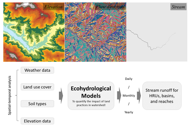
Changes in land use and climate affect ecosystem sustainability by altering the availability of natural resources. Ecohydrological models can quantify the effect of these changes on hydrological and ecological processes. However, integrating various key ecohydrological model components is often difficult for many interdisciplinary students and researchers. This seminar will provide students and researchers with skills to efficiently integrate spatial, weather, and hydrology data for building an ecohydrological model using the open-access software programs SWAT (Soil & Water Assessment Tool) and QGIS.
The SWAT is a basin-scale ecohydrological model. It simulates the quality and quantity of water resources for predicting the environmental impact of land use, land management practices, and climate change. Users can apply SWAT to simulate water and nutrients cycle in agricultural landscapes and assess the environmental effects of best land management practices and policies. Digital elevation model is a key input to develop subbasins that are further discretization using land use and soil types. Areas with the same soil type and land use form a Hydrologic Response Unit (HRU), which is a basic computational unit in SWAT to assess hydrologic response to land cover change.
Seminar instructor will introduce basic concepts of organizing data, knowledge of data inputs, and uses of necessary software interfaces. Participants will gain hands-on experience building, calibrating, and validating the SWAT model in QGIS. Participants will bring their own personal laptops. Organizers will alert prior to the workshop via email of specific software requirements for participation in the seminar.
When
Wednesday, April 17, 20193:00pm to 4:30pm
Where
East Learning Lab A 2112, Hill LibraryInstructors
 Kunwar K. Singh
Accessibility
If assistive technology, live captioning, or other accommodations would improve your experience at this event, please contact us. We encourage you to contact us early about this to allow sufficient time to meet your access needs.