Transportation Related Data
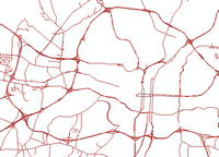
'State maintained roads' in the Raleigh area.  Does not include city maintained streets.  See NC Dept. of Transportation entry below.

Street centerlines are necessary for many mapping and GIS analysis projects. Most street centerline data include attributes of address ranges for each street segment, which are required for geocoding addresses.

Some of the collections listed below also include other transportation related datasets.

Summary Table of Transportation Related Collections Collections

The table below summarizes various available street and transportation related collections.


Collection Name and Links Usage Notes
County-based Street Centerlines

See the NC County GIS Data Directory for the following holdings and access links:

  • Use the "Lib Web" links to see NC State University Libraries' holdings by year. Contact Data Services for access.
  • Use the "Web Map" links to view streets on county mapping websites.
  • Use the "Dwnld" links to download street files from county websites.
  • Use the ims file or WMS links to "stream" imagery into ArcMap or other viewing applications.


  • The most detailed, accurate, and up-to-date available when acquired directly from a County's download site
  • Data for non-NC counties are best found by doing a Google Search using [county's name] [state] GIS streets
  • Most NC local data are projected to NC Stateplane, NAD83, feet, but there are exceptions
NC Dept. of Transportation

NC DOT provides regularly updated statewide transportation data:


  • "State maintained roads" means it does not include city maintained streets. This data is depicted in the graphic above showing state maintained roads in the Raleigh area.
  • See the Libraries' NC DOT Data webpage for much more info, including a full description of the ISRN data, which include state and municipal streets statewide.
NCStreetMap.com - Centerline Data Distribution System

NC Street Map / CDDS(This link is broken. We're working on fixing it) is a website for sharing street data among public agencies, nonprofit and governmental organizations. NC State University affiliates may contact Data Services for assistance.

  • You must create an account and get approval before access is granted.
  • Local governments are HIGHLY encouraged to submit their data, and will benefit by having many fewer requests from other agencies.
ESRI Data and Maps

ESRI Data and Maps includes highway data for North America as Streetmap NA. Also data for Mexico, and Europe are available.

  • Be sure to read the metadata for Streetmap NA to determine it's effective year - e.g. the 2008 release is actually 2003 Tele Atlas streets.
  • Streetmap releases prior to 2008 were called Streetmap USA, and only included US streets.
US Census TIGER data

TIGER data has been produced by the US Census Bureau for decades, and includes street centerlines, among many other features. Coverage is nationwide.

  • See the Libraries' TIGER page for details and download links.
  • The most recent TIGER data is no longer in "TIGER" format, but are shapefiles
  • Recent releases predominantly use county produced street centerlines as source data
  • Older TIGER data are available, but tend to have very low positional accuracy
National Transportation Atlas Databases (NTAD)

This data compilation is released annually by the US Bureau of Transportation Statistics (BTS) and is free to the public.

NTAD 2004 is the latest NTAD data cataloged in GIS Lookup. Later NTAD versions will be cataloged as time permits.

NC State University Libraries has NTAD CDs and DVDs from 1998 to the present, except for years 2000 and 2007. Currently (March 2009), data from the 1998 and 2008 NTADs may be downloaded from the BTS website.

  • The content of NTAD has expanded over the years. The 2008 version includes various transportation facilities (airports, rail stations, ports, bridges, weigh stations, etc.), freight networks, hazardous material routes, National Highway Planning Network (proposed future highways), rail networks, waterways, air quality non-attainment areas, and various political boundaries.