It’s all about geography, Nov. 10-16
November 4, 2019
All maps lead to the Libraries on Wednesday, Nov. 13 for GIS Day. GIS (geographic information systems) Day is the centerpiece of Geography Awareness Week (Nov. 10-16), which features special hands-on workshops, demonstrations, and a mapathon—as well as interactive “Where do you call home?” maps at both the Hill and Hunt Libraries.
The full schedule is below. All events are free and open to the public unless otherwise noted.
Tuesday, November 12
-
Mapping in Tableau workshop, 10:00 a.m.-11:30 a.m. in the Hill Library ITTC Lab 2 (pre-registration required). This workshop will introduce basic mapping features in Tableau and teach best practices in geospatial visualization.
Wednesday, November 13: GIS Day at the Hunt Library
-
GIS content takeover of the Hunt Library video walls (all day)
-
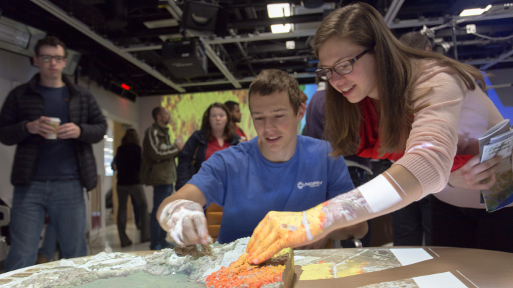
Explore the Tangible Landscape, 1:00 p.m.-4:00 p.m. in the Hunt Lobby. By sculpting the topography with your hands, the Tangible Landscape platform can be used to solve problems such as tracking emerging infectious diseases and modeling coal ash spills. The Center for Geospatial Analytics is bringing the Tangible Landscape to Hunt Library so you can try your hand at molding the landscape and sculpting the earth’s topography, while seeing the digital model change in real time.
-
GIS Day open house, 1:00 p.m.-4:00 p.m. in the Hunt Library Lobby. Visit tables from campus partners including Facilities, Transportation, Center for Geospatial Analytics, the Geology program at the Department of Marine, Earth, and Atmospheric Sciences, and the Libraries. The Libraries table will feature fun Makerspace stuff, a virtual reality experience, cookies, and swag giveaways.
-
“From the Top of the Atmosphere to the Bottom of the Ocean,” 2:30 p.m. in the Hunt Library Game Lab. In this visualization demonstration, Joseph B. Zambon (Research Assistant Professor, Ocean Observing and Modeling Group, Department of Marine, Earth and Atmospheric Sciences) uses a coupled numerical model to accurately represent the entire marine coastal environment. At NC State, the Ocean Observing and Modeling Group has developed an operational model that uses physics to represent complex interaction between the ocean, atmosphere, and wave environments for the entire east coast, Gulf of Mexico, and Caribbean Ocean.
-
Humanitarian Mapathon, 4:00 p.m.-5:00 p.m. in the Hunt Library Game Lab. Drop in and join a crowd-sourced effort to provide maps that assist in disaster preparedness and humanitarian and crisis relief. Many parts of the world most vulnerable to humanitarian crises such as natural disasters, epidemics or conflict are not mapped. You’ll learn how to contribute to OpenStreetMap, the “Wikipedia of Maps.” No mapping experience is needed!
-
Triangle GISocial, 6:00 p.m.-8:00 p.m. at the City of Raleigh Museum (220 Fayetteville St.). Join an informal social networking event for Triangle area geospatial students (Duke, NC Central, UNC, and NC State) and area geospatial professionals, hosted by the NC State Center for Geospatial Analytics and sponsored by Geo Owl. Please RSVP at this link to help the organizers plan.
Thursday, November 14
-
Geospatial Forum with Matthew Dusch and Harrison Webb from Esri Charlotte, 3:30 p.m.-4:30 p.m. in Jordan Hall. Two Enterprise Support and WebGIS Analysts from Esri Charlotte will present “Deploying Enterprise GIS Solutions in the Cloud.”
Friday, November 15
-
Coffee & Viz - Urban Panorama: t-SNE Street Feature Mapping Tool, 9:30 a.m.-10:30 a.m in the Hunt Library Teaching and Visualization Lab. Faculty members in the Visual Narrative Initiative Frederico Freitas, assistant professor of History, and Todd Berreth, assistant professor of Art + Design, are developing a t-SNE Street Feature Mapping Tool to help researchers use historical streetscape images to understand the spatial distribution of urban features across cities. Freitas and Berreth will discuss the underlying computer vision and machine learning systems powering the tool and demonstrate the interactive visualization techniques the tool provides.
Check for updates to the schedule here.