Urban High Resolution Digital Orthophotos (2002)
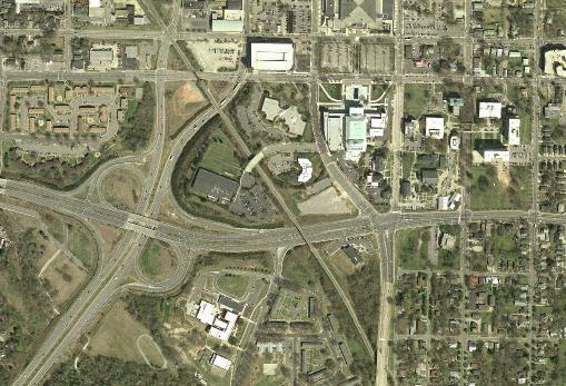
The U.S. Geological Survey (USGS) has acquired high resolution color orthoimagery for the 133 most populated metropolitan areas of the United States as an essential element of The National Map. In North Carolina, the Raleigh/Durham/Chapel Hill and the Charlotte metropolitan areas were acquired in 2002. The Greensboro/Winston-Salem/High Point area was acquired in 2004. These true-color orthoimages have a resolution of 1/3 meter, or approximately 1 foot. For more information, see the USGS Factsheet.
Networked Data
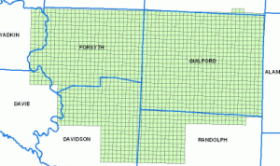
Images are available on the Geodata server for NC State University affiliate download. The Raleigh/Durham/Chapel Hill metropolitan area (coverage indicated below, right) files are in the /doqq/raldur02 folder. The Greensboro/Winston-Salem/High Point (coverage indicated below, left) are in the /doqq/gbows04 folder. Direct ftp link: ftp://geodata.lib.ncsu.edu/doqq/.
 |
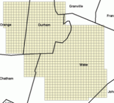 |
| Extent maps for the Triad and Triangle image tiles |
Usage Notes
- The best way to determine which files you need is to overlay the index shapefiles in each folder with other existing data. Use the "USNGID" attribute to determine the names of the images you need. Then download the .ecw and .aux file(s) from the appropriate subfolder(s).
- To view .ecw files in ArcView 3.x, you will need to download and install a free ECW plugin from the ERMapper Download Site(broken link). Other plugins if necessary are available for various other graphics and mapping software, such as Photoshop and AutoCad.
- The images are in UTM spatial reference coordinates, NAD83 datum. However, ArcMap will project them "on the fly" to whichever coordinate system you've defined for your data window. Thanks to 3001 for their RAGE tool (no longer available online) that enabled making .aux files.
- The .ecw files are greatly compressed in file size with very minimal loss of image quality. If you must have the original TIF images for your work however (about 70 MB each), contact Data Services. Thanks to the Town of Cary GIS(broken link) for compressing these orthos and giving a copy to NC State University Libraries.
Public Download
Urban High resolution orthophotography for the 133 metropolitan areas of the US may be downloaded from the National Map Seamless Data Distribution System(broken link) in TIF format (very large files). The steps are:
- Click the link "View and Order Datasets, United States Viewer"
- Zoom in approximately to your city of interest
- Scroll the "Display Legend/Layers" list (right side of screen) to turn on the Hi-Res Ortho for your city of interest and turn on/off any other layers you want.
- Scroll all the way down to the bottom of the "Display Lagend/Layers" list, and hit "Refresh Map"
- Zoom in/out/pan to explore the data and decide what you want to download
- When you are ready to download data, scroll the "Download Layers" list (right side of screen) unchecking the default layers you may not want, and turn on the Hi-Res Ortho layer.
- On the left side of the screen, click on the "Select by Rectangle" Download tool.
- Drag a box with the cursor over the area you want. Notice the message below the map that a Green box means the area is still small enough for direct download. A red box means the area is too large for download and must be ordered on CD. Adjust your box accordingly.
- A webpage will appear where you can download the images.
For further information about orthoimagery data, please contact Data Services.