Nash County GIS Data
Feature Data Layers obtained 2001
The following county-wide feature data layers are available for Nash County. The data are in shapefile format, State Plane 1927/feet.
Feature Data
| Coverage | Description | File Size | Brief Metadata |
|---|---|---|---|
| centerlines | Street Centerlines | 9.8 mb | centerlinesl.txt |
| cl-etj | City Limits/ETJ | 0.7 mb | cl-etj.txt |
| fire | Fire Districts | 2.5 mb | fire.txt |
| grid400 | 400' Scale Orthophoto Grid | 0.14 mb | grid400.txt |
| parcel | Tax Parcels | 145.7 mb | parcel.txt |
| rescue | Rescue Districts | 1.7 mb | rescue.txt |
| zoning | Zoning | 34.3 mb | zoningp.txt |
Digital Orthophotos
As of 2001, digital orthophoto flights had been done in 1997 by L. Robert Kimball & Associates. The entire county was done at '400 scale. Developed areas were done at 100' foot scale. The original data is in TIFF format, State Plane NAD 27/feet and is available on 44 CD-ROMs. Data availability by image resolution is shown below:
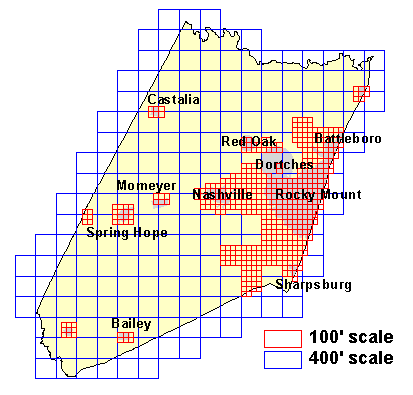
Image index shapefiles (nash100.shp [100'], nash400.shp [400'], and nashall.shp [merged]) for each resolution are available on the Geodata server server at https://proxying.lib.ncsu.edu/index.php?url=http://gisdata.lib.ncsu.edu/localgov/Nash_County/2001/meta/ (data in State Plane NAD 27/feet).
An online clickable map index is also available.
Explore
Library Data Services
Learn About GIS
Can't find data you're looking for?
Contact a Data Services Librarian for help.